Changing Face of Norwich
- Prince of Wales Road
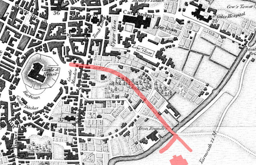
By 1850 trains were linking Norwich to both London and many local towns and cities, including Yarmouth and Ipswich. As goods and people flowed into Thorpe Station it was soon realised that the somewhat narrow Rose Lane, the main road connection the station to the City, formed a bottle neck. In particular, there was clearly a need to establish a route between the station and the Market Place.

Longman's map of Norwich 1819.
It can be seen that this area was largely horticultural which meant that building Prince of Wales Road did not necessitate the demolition of buildings. The dotted line that is now the Yarmouth Road appears to still be in the planning stage but the Millard and Manning map of 1830 shows it as a completed road.
It can be seen that this area was largely horticultural which meant that building Prince of Wales Road did not necessitate the demolition of buildings. The dotted line that is now the Yarmouth Road appears to still be in the planning stage but the Millard and Manning map of 1830 shows it as a completed road.
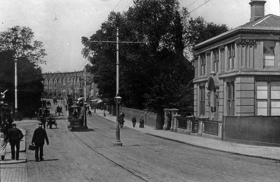
The first scene dates from c.1900, just after the trams start to run.
At the top of the road, we just catch a glimpse of a row of large houses with low-pitched gables (described rather unkindly by the architectural historian Pevsner as resembling ‘an unimaginative seaside terrace’) which still line the street. It had originally been hoped that buildings of a similar design would continue down the road and become high-class residences – neither aspirations were realised. In fact, when this photo was taken we can see that south of St Faith’s Street there seems to be just one building fronting Prince of Wales Road. We know the building is no longer there – but what was it? It was in fact part of the Hills & Underwood Distillery and Vinegar Works, which, as can be seen on the 1884 map, occupied a huge area. A vinegar works had first been established on this site in 1762, and it remained here until 1911 when the works were closed and subsequently demolished.
At the top of the road, we just catch a glimpse of a row of large houses with low-pitched gables (described rather unkindly by the architectural historian Pevsner as resembling ‘an unimaginative seaside terrace’) which still line the street. It had originally been hoped that buildings of a similar design would continue down the road and become high-class residences – neither aspirations were realised. In fact, when this photo was taken we can see that south of St Faith’s Street there seems to be just one building fronting Prince of Wales Road. We know the building is no longer there – but what was it? It was in fact part of the Hills & Underwood Distillery and Vinegar Works, which, as can be seen on the 1884 map, occupied a huge area. A vinegar works had first been established on this site in 1762, and it remained here until 1911 when the works were closed and subsequently demolished.
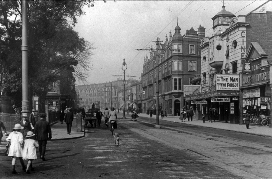
South of St Faith’s Road, buildings now line Prince of Wales Road. Of particular note is the Electric Theatre.
Opened in 1912 this was Norwich’s second purpose-built cinema.
As it is featuring the film ‘The Man Who Forgot’ (starring James Knight and Marjorie Villers) we can fairly accurately date the image to 1919.
On the opposite side of St Faith’s Road we see Alexandra Mansions, designed by Edward Boardman in 1889 as Norwich’s first -purpose built flats.
Similar to the terraces at the top of the Road, its aspirations to become a prestigious address were never realised, perhaps not helped by the fact the ground floor had always been intended for commercial use.
In 1923 part of the building was converted into the foyer of what was originally the Regent Theatre (the theatre itself was constructed behind).
It later evolved into one of Norwich’s great dream palaces of the 1950s/60s the Regent Cinema (part of the ABC chain)
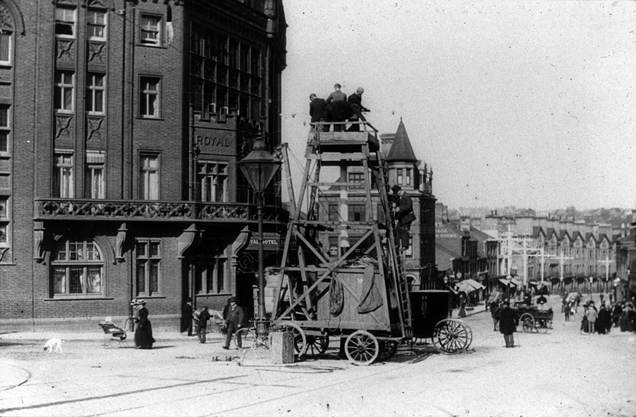
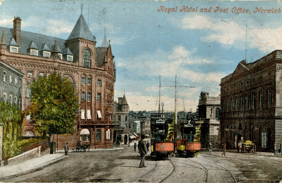
The link between Prince of Wales Road and Castle Meadow was deemed worthy of being graced by grand buildings, designed to impress visitors to the City who had arrived at the railway station.
Our first photo (c.1899) is not dominated by these impressive edifices, but by a four-wheel tower wagon.
This piece of equipment proved especially useful for workman installing a very important part of Norwich’s new tramway system
– the overhead wires (the source of electric power for the wagons).

We also have a view of three striking buildings which still grace the landscape today:
Hardwick House, the Agricultural Hall and the Royal Hotel.
The first of these to be erected was Hardwick House, built in 1866 as the home of the Crown Bank.
The building was commissioned at a cost of £13,000 by Sir Robert Harvey (senior partner in the bank) and is now named after its architect (P. C. Hardwick).
Sadly, four years after taking up occupation of their new premises the bank crashed.
When this photo was taken the building was owned and occupied by the Post Office.
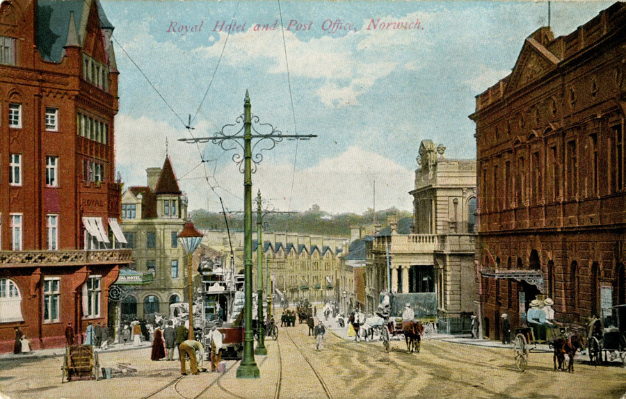
Hardwick House is a rather splendid building faced by white/grey ashlar stone and incorporating a portico supported by iconic columns, a large upper balustrade and upper pediment.
This contrasts in design with the adjacent red-bricked Agricultural Hall (now Anglia House).
The foundation stone for this imposing, three-storey building (designed by J.B. Pearce) was laid on March 1882.
Somewhat impressively, less than eight months later, on Thursday 16th November HRH the Prince of Wales was in the City to both officially declare it open and to visit the first agricultural show held here.
The building was commissioned by the Norfolk Fat Cattle Association who intended to use it for it for exhibitions, but also to generally support the needs of the county’s ‘agricultural fraternity’.
However, it also hosted non-agricultural events and put on a host of entertainments.
Most notably at one time it was home to a rollerskating rink whilst the building itself had a concert room for:
‘The production of comedies, dramas and farces… Sensational dramas will not be attempted as the manager has not the space for the inclination to produce them.’
On the opposite side of the road we see Edward Boardman’s grand Royal Hotel.
Opened in November 1897 it replaced the coaching inn of the same name on the Market Place (the licence transferred across).
Built near the railway station in many ways it was a symbolic building representing the unrelenting march of progress – by now long-distance coach travel had been replaced by steam.
It was a luxurious six-storey building costing some £23,500, and even housed a winter garden to separate residents from general customers.
The coloured postcards, allows us view these buildings and the tram system in all of their glory.
Although the buildings now have different uses, and have been altered, the scene is still very recognisable. There are two major differences.
Firstly on the Castle Meadow/Bank Plain corner stands an insignificant structure,
In 1929 this will be replaced by the Gurney (later Barclays) Banks’ monumental new hall.
Secondly, this busy junction is now dominated by a new form of transport, the motor vehicle.


